
By Barbara Heimlich
Editor
Sources: Climate Risks Reports for Every Property in the US ; Connecticut Institute for Resilience & Climate Adaptation (CIRCA); David Murphy, Manager of Water Resources Planning, Milone & MacBroom; Diane Ifkovic, State NFIP Coordinator, Connecticut Department of Energy and Environmental Protection; Katie Lund, CIRCA Director of Engagement
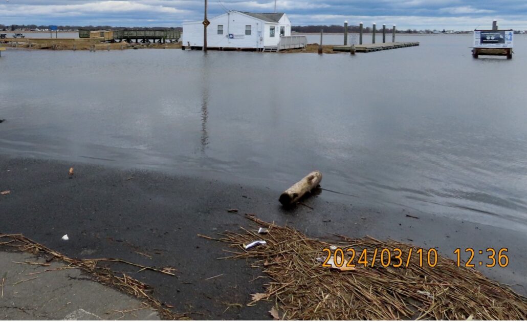
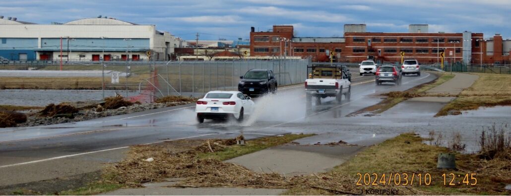
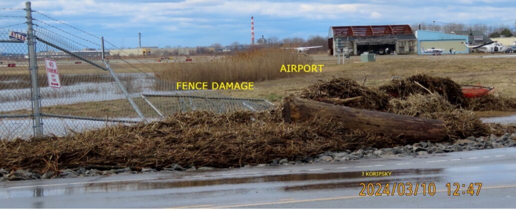
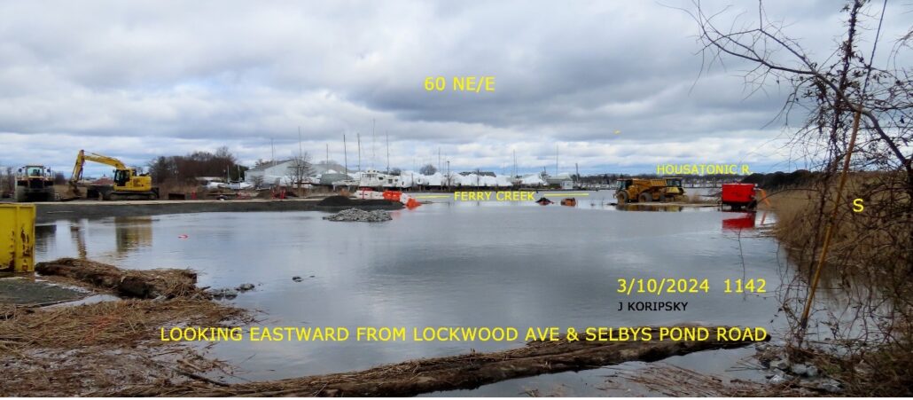
Is your property at risk for coastal flooding? We are not talking about flooding on your street or property from blocked/clogged sewer drains. This is flooding that occurs when we have sustained heavy rainfall, high tides, storm surges. The following photos were taken Sunday, March 10th following a heavy rainstorm.
Connecticut Precipitation, National Weather Service Offices Preliminary Precipitation Data (inches) by County Precipitation Data through January 2024
Fairfield County:
Rainfall: 6.65
Departure: 3.07
Percent: 186
Normal: 3.58
Prognosticators are not expecting the number of weather events (heat, rainfall, snow) to lessen, and warn that we all should be prepared for severe weather events.
What will climate risk cost you? Go to https://riskfactor.com/
There you will find leading physical climate risk modeling for any property in the U.S. You will get a comprehensive risk overview and access detailed reports about past, present and future risks as well as high-level solutions to help mitigate risk. Free for all residential properties. Risk Factor™ is a product of First Street™, the leading provider of climate risk data. They leverage the most advanced climate science and engineering approaches to quantify and communicate the risk for every property in the country.
https://firststreet.org/our-mission
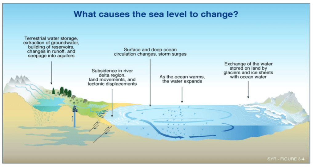
Coastal Flooding and Waves Overview
CIRCA works to enhance coastal resilience to coastal flooding in Connecticut. Coastal flooding is caused by waves, storm surge, and high tide, particularly with increased sea levels. In coastal areas where there are also rivers, rainfall contributes to coastal flooding as well.
Impacts of Extreme Weather and Climate Change on Coastal Flooding
Coastal flooding occurs during hurricanes and less intense storm events, i.e. tropical storms or nor’easters, due to waves, storm surge, and rainfall. As the sea levels rise, the frequency of coastal flooding during all storms will increase as well as the total flooded area at high tide. Flooding that occurs during small storms or at high tide is often referred to as “nuisance flooding.” As sea levels rise, the frequency of nuisance flooding will also increase.
CIRCA and Coastal Flooding
CIRCA’s research projects investigate the particular impacts of coastal flooding on Connecticut’s shoreline. The varied features of Connecticut’s coastline, its marshes, small beaches, and rocky headlands, determine how and where flooding will occur. CIRCA’s research incorporates these coastal features as well as the unique ocean dynamics of Long Island Sound to determine wave height and force, projected storm surges, the frequency of flooding due to those storms, and sea level rise.
CRS (Community Rating System) technical assistance. As a result of this funding opportunity, several municipalities were assisted to varying degrees.
Municipal Assistance for FEMA’s Community Rating System Report: Project Description
Through this opportunity, some communities were interested in pursuing CRS points for a wide range of activities, while others requested more in-depth assistance for a few select CRS activities. The towns of Guilford, Newtown and Stratford received assistance with open space mapping, outreach activities (brochures), or preparation of documentation for CRS entry. These three communities received assistance as an individual community on only a small number of activities in order to help boost their current CRS rating.
Overall, these participating communities were able to work toward increased CRS points and advance their CRS rating or enter the program, which will ultimately reap the benefit of lower flood insurance premiums on a community wide basis.
The Federal Emergency Management Agency (FEMA) administers the National Flood Insurance Program (NFIP) to provide flood insurance within communities that adopt and enforce floodplain regulations. Communities may choose to enter into the National Flood Insurance Program’s Community Rating System (CRS) in order to reduce the cost of flood insurance premiums for their property owners. Communities participating in the CRS Program go above and beyond the minimum standards and, depending on their level of mitigation efforts, can garner insurance premium reductions from 5-45%.
In response to the rising interest in the CRS program, CIRCA allocated funding to support communities with CRS entry and class advancement. CIRCA partnered with Connecticut Department of Energy and Environmental Protection staff to advise Milone & MacBroom about which municipalities could benefit and take advantage of CRS technical assistance. As a result of this funding opportunity, several municipalities were assisted to varying degrees.
CIRCA Local Sea Level Rise Scenarios for the State of Connecticut
In 2012 NOAA released global sea level rise scenarios that were referenced in Connecticut state statute requiring that sea level rise be considered in state and local plans of conservation and development and natural hazard mitigation plans. That same statute charged CIRCA with updating the scenarios to be local for the state of Connecticut.
CIRCA recommends that Connecticut plan for the upper end of the range of values projected of sea level rise, or up to 20 inches (50cm) of sea level rise higher than the national tidal datum in Long Island Sound by 2050, and that it is likely that sea level will continue to rise after that date. The Institute also recommends that the scenarios be updated at least every 10 years, or more frequently, to incorporate the best available science and new observations.
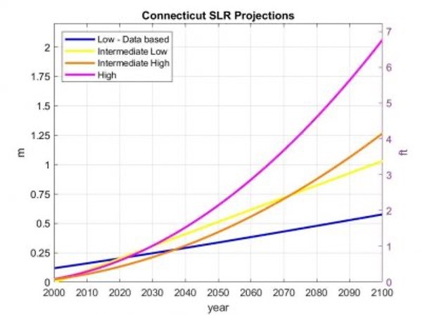
Sea level rise projections for Connecticut based on local tide gauge observations (blue), the IPCC (2013) RPC 4.5 model simulations near Long Island Sound (yellow line), the semi-empirical models (orange line) and ice budgets (magenta line) as in CPO-1. Link to full report is below.
The following list of projects includes all Sea Level Rise Projects UCONN CIRCA has participated in or funded:
- Sea Level Rise Connecticut Final Report
- CIRCA’s Connecticut sea level rise projections: ODonnell 2017 Technical Report Executive Summary, Presentation (with audio) and slides only.
- CIRCA’s blog, “Current Policies on Sea Level Rise in Connecticut” provides an overview of PA 13-179 and the NOAA CPO-1 report’s global sea level rise projections.
- U.S. Department of Commerce. National Oceanic and Atmospheric Administration. Sea Level Rise and Nuisance Flood Frequency Changes around the United States, by William Sweet et al., Technical Report NOS CO-OPS 073, NOAA. Silver Spring, MD, 2014.
