
The plan to save the south end of Stratford.
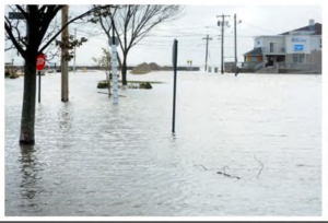
Seven years later we continue to flood.
In 2016 the Town of Stratford commissioned MetroCog and GZA GeoEnvironmental Inc to create a
“The Town of Stratford Coastal Community Resilience Plan” (The Plan). The Plan was intended to provide the roadmap to make the community more resilient – economically, socially and ecologically – to coastal flooding and the effects of sea level rise. The Plan was funded through a Community Development Block Grant Disaster Recovery (CDBG-DR) grant.
We will be running a series of articles highlighting the finding of this 254 page report. We will share direct quotes from the report.
We will report the findings of The Plan in a similar format as the plan itself.
https://www.stratfordct.gov/content/39832/39846/39923/40885.aspx
We will reach out to Town leadership to understand 7 years since the report was provided to the town, the progress we have made and the road map forward.
PLAN PURPOSE
“Positioned on the shores of Long Island Sound and the Housatonic River, Stratford is truly a coastal community. It is blessed with coastal resources, including beaches, tidal wetlands and estuaries. It is characterized by water-dependent activities such as swimming and beach-going, nature walks, marinas, yacht clubs, and boat launches. It boasts publicly-accessible open space with broad vistas of the Sound and River.
However, many of Stratford’s 51,500 residents and approximately two-thirds of its commercial properties are located in areas where the ground surface elevation is just a few feet above high tide. Hurricane Sandy, which flooded much of the Town in 2012 and resulted in millions of dollars of damage, was only the most recent of many storms that have impacted the Town. As devastating as the flooding was during Hurricane Sandy, the elevation of the flood waters during Sandy was lower than the Base Flood Elevations (BFEs) currently predicted by the Federal Emergency Management Agency (FEMA) and considered the minimum standard for flood protection regulations and insurance.”
The water levels within Long Island Sound are, unequivocally, rising.
More than 50 years of measurements at the National Oceanographic and Atmospheric Administration (NOAA) Bridgeport tide gage indicate that, at the current rate, sea level at Stratford is rising slightly less than 1 foot per century. However, the rate of sea level rise (SLR) is expected to increase at a much greater rate. The rise in the sea level will have devastating impact on our coastal communities.
WHO PUT THIS REPORT TOGETHER.
This Coastal Climate impact assessment and mitigation plan was put together by
TOWN OF STRATFORD ENGINEERING DIVISION
John Casey, P.E., Town Engineer
TOWN OF STRATFORD PLANNING AND ZONING
Jay Habansky, Planning and Zoning Administrator
TOWN OF STRATFORD CONSERVATION DIVISION
Christina Senft-Batoh, PhD, Former Conservation Administrator
METROCOG
Matthew Fulda, Regional Planner
PLANNING, DESIGN, AND ENGINEERING TEAM
GZA GeoEnvironmental, Inc.
The Cecil Group
Jamie Caplan Consulting, LLC
The Environmental Reporting Group – a group of Stratford Citizens working with the Stratford Crier, with an interest in preserving our town and protecting our environment, will be breaking this 254 page document into bit size pieces to allow us all to understand where we are and envision a way forward.
In each weekly report we will high light an area of concern, highlight the potential degrees of impact and share the findings of the study with the associated plan.
We will try and engage our town leadership to best understand where they are incorporating this report into Stratford’s future planning.
We hope you find this reporting helpful.
The Stratford Reporting Group

7 yrs of study and no plan to protect the South end from flooding? What is wrong with this picture?