
Part 2
Goals and Strategies presented in 2016 Resilience Plan
The key objectives of the resiliency plan are
Goal 1: Ensure that the Town continues to be a livable community with future economic opportunity, while supporting Town values;
Goal 2: Make the social, economic, and environmental systems more resilient to coastal flooding and sea level rise;
Goal 3: Support the Town vision presented in the current Plan of Conservation and Development;
Goal 4: Increase the coastal resilience of public infrastructure;
Goal 5: Increase public awareness and understanding of coastal risks and resiliency; and
Goal 6: Provide guidance for future investment, planning, and regulatory change.
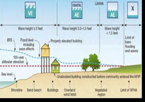
COASTAL HAZARD OVERVIEW
Stratford includes large areas of low-lying, developed land south of Interstate 95. Ground surfaces elevations range between Elevations 5 and 9 feet NAVD88. These areas are particularly vulnerable to coastal flooding.
Waterways like Ferry Creek and the Marine Basin also provide points of entry for coastal flood waters that progress inland.
The contributing factors that most significantly influence coastal flooding today and will continue to influence flooding in the future include the following:
SEA LEVEL RISE
Sea level rise (SLR) will affect future tide elevations as well as the frequency and elevation of coastal storm surge flooding. The Plan utilizes three (3) SLR projections (Low, Intermediate, and High) developed by the United States Army Corps of Engineers (USACE) to predict the range of sea level rise for the years 2015, 2040, 2065, and 2115.
The three projections vary based on different assumptions about greenhouse gas emissions, ice melt, and other factors. However, each of these projections are equally probable. By the year 2065, SLR is projected to range from 0.4 foot to 2.2 feet. By the year 2115, SLR is projected to range from 0.8 foot to 6.2 feet.
TIDES
Except along beaches and near tidal wetlands, the effects of tidal flooding on Stratford are currently minimal. However, unless flood controls are implemented, the Sikorsky Memorial Airport may flood on a daily basis during high tides by the year 2065. Mean High Water (MHW) tidal elevation, assuming the High SLR projection for 2115, is approximately five (5) inches higher than the peak flood observed during Hurricane Sandy and would result in flooding similar to the flooding that occurred during Hurricane Sandy – but on a daily basis.
EXTREME FLOODS
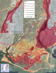
Extreme coastal flooding water levels resulting from storms such as nor’easters, tropical storms, and hurricanes. GZA’s flood models, which are based on the results of the USACE’s North Atlantic Coast Comprehensive Study (NACCS), predict the coastal flood elevations and inundation limits for the years 2015, 2040, 2065, and 2115. The model results indicate that much of the Town, especially areas located south of Interstate 95, will be significantly flooded during periods of extreme water levels. GZA’s flood models also demonstrate how coastal flooding of interior areas originates at specific coastal entry points of Stratford, including:
- The Marine Basin, North of the Army Engine Plant Levee,
- Shore Road,
- Ferry and Johnsons Creek,
- Great Meadows,
- Long Beach,
- and South of Short Beach
Areas in Red and Orange are at sea level or slightly above and are at high flooding risk now.
