 Conducted on Wednesday, November 9th
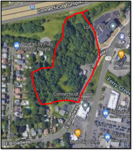
The United States Environmental Protection Agency (EPA) in conjunction with the Town of Stratford Health Department conducted a virtual meeting for neighborhood residents bordering the Morgan Francis property at 576-600 Elm Street. An area of approximately 5 ½ acres.
Morgan Francis Flagpole, Inc. was in operation from 1948 to 1980. The property is grassy, with some woods, a small building, and pavement.
The purpose of the meeting was to announce the planned remedial strategy to address Raymark Waste buried at 576 and 600 East Broadway, on property historically referred to as Morgan Francis. These parcels total just under 6 acres and abut residential properties along Blakeman Place, Harris Court and East Broadway, as well as the upper portion of Ferry Creek and Interstate 95.
Representatives from EPA (Jim DiLorenzo and Dan Keefe); Mike Rooney and Rachel McFee from the United States Army Corps of Engineers (USACE); Tony Alevo from the CT Department of Energy and Environmental Protection (CTDEEP); the CT Department of Public Health (CTDPH) and the Town of Stratford (Alivia Coleman, Health Program Associate) participated in the presentation.
Sometime prior to 1970, about 43,000 cubic yards of Raymark Waste was buried on the property to fill prior wetlands. In the early 1990’s EPA covered the Raymark Waste area with clean soil and the property is now heavily vegetated. A perimeter fence was also installed to inhibit access.
The EPA is proposing to consolidate Raymark Waste from the upper portion of Ferry Creek and adjacent land owned by the Connecticut Department of Transportation (CTDOT) and construct a low-permeability cap suitable to allow safe reuse of the property for recreation.
According to DiLorenzo the property is not suited for development as there is between 20-30 feet of peet which presently supports the vegetation and wildlife on the property. All of the vegetation will be removed.
What is Raymark Waste?
Raymark Waste is a manufacturing waste material from the former Raybestos Industries, Inc. facility, which was located at 75 East Main Street (now Stratford Crossing). From about 1920 to 1980, Raybestos manufactured brake and clutch pads for the automotive industry. Raymark Waste contains about a dozen chemicals known to be hazardous. Raymark Waste was historically used as fill material at various wetland and low-lying properties in Stratford, including Morgan Francis.
The definition of Raymark Waste is a soil sample containing both asbestos (above 1%) and lead (above 400 parts per million (ppm)) and either polychlorinated biphenyls (PCBs) (above 1ppm) and/or copper (above 288 ppm).
Have We Been Exposed to Raymark Waste?
No. The area of buried Raymark Waste on Morgan Francis was covered with more than 6 inches of clean loam as a temporary measure back in the 1990’s, and is now covered by mature grass, trees and other vegetation. This prevents direct contact and any possible air-borne dispersion of chemical particles. There is also a perimeter fence and no evidence of trespassing on the primary property.
Why Dig-Up and Remove Raymark Waste?
EPA decisions regarding cleanup are based on the potential for exposure to hazardous material. If EPA were to leave Raymark Waste as is at Morgan Francis (and other properties around town), Raymark Waste could become exposed in the future through erosion or other human activities that disturb the soil.
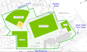
To prevent future exposure, Raymark Waste from nearby properties in town will be excavated and consolidated (approximately 45 Thousand Cubic Feet of Raymark waste) at Morgan Francis to be safely covered with a 4-foot thick low- permeability capping system which will allow for safe recreational use of the property. There are plans to consolidate Raymark Waste from an adjacent DOT parcel and uppermost Ferry Creek area (about 5,000 yds).
Environmental Sampling Proposal
Approximately 70 soil borings and 150 soil samples will be collected around the perimeter of the Morgan Francis property using direct – push soil sampling methods.
Minor brush removal will be completed to access sample locations. All samples will be analyzed for Raymark Waste constituents, and CT RSR criteria at select locations.
Why?
To determine the limits of the cap and support design and characterize areas they are not going to cap.
The estimated Start Date: December, 2022, with a projected duration of 10 days.
Proposed Recreational Plans
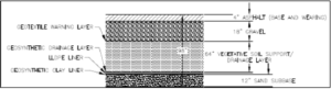
The engineered capping system is resistant to erosion and greatly limits movement of chemicals into groundwater. By Superfund Law, the engineered cap will be indefinitely maintained and reviewed to ensure it remains protective of the community.
Cap Diagram:
Issues Raised by Neighbors
Q: Why are you clear cutting all of the vegetation (trees)? Are you going to plant trees on the site?
No, because mature tree roots, which would be more than 4 feet would penetrate the low-permeability cap. There will be trees and shrubs planted around the perimeter of the site.
Q: How do you know the cap is intact and functioning properly after years?
There will be a series of monitoring wells around the cap, which will be monitored in real time by the State of Connecticut DEEP indefinitely.
Q: Why cap in place instead of removing the material?
There is a large volume of waste on the property. We are removing smaller areas of waster (less than 10 thousand feet) around town.
Q: What kind of development is not a good idea on this site?
The site cannot support commercial and residential development as the site is spongy, which lends itself for recreational.
Q: How will the cap interface with the residential area surrounding it? Note: Question asked by a Blakeman Place resident)
The perimeter around the site will have a clean buffer, of approximately 10 feet (which may change one design approved) where mature trees will be). Blakeman Place site is higher than the property, and fencing for security would be considered should residents want it.
Q: How are you going to handle removing and monitoring waste to make sure there is no airborne hazards?
We are not going to excavate waste, we are going to peel back waste from the perimeter and most will remain in place, and will be capped. We will have air-monitoring devices around the cap with real time air quality monitoring, and we will keep the material wet so there is no dust.
Q: If once capped the elevation will be 6 feet what will prevent flooding of property surrounding the site?
The cap will have drainage and all water will go into Ferry Creek.
Q: How safe will our drinking water be?
Our drinking water comes from Trap Falls, not wells. Our drinking water will be safe.

This seems like a well thought out plan. Since the space will be wide open. Is there an opportunity to create a solar park here on some of the space, to collect energy and offset our dependence on carbon based fuels?